The 5 flood danger levels and recommended behaviour
The FOEN has the legal mandate to warn of floods using a five-level danger scale. The danger levels provide information on the severity of the event, its potential effects and recommended actions.
Mandatory broadcasting may be stipulated for level 4 and 5 warnings and they must then be broadcast by the state-licensed radio and TV stations.
The meaning of the flood danger levels
 Danger level 1: Low danger or none
Effects
The hazard is unlikely to disrupt traffic or cause damage.
Public guidance
You can remain in the vicinity of lakes and rivers, but remain cautious at all times.
Further information
- Rivers and streams: The discharge level remains below that of an event that occurs once every two years on average.
- Lakes: The water level is within the usual range.
 Danger level 2: Moderate danger
Effects
Localised flooding is unlikely, but may occur.
Public guidance
- It may be dangerous to be in the vicinity of lakes and rivers. As a precaution, maintain a safe distance.
- Keep an eye on the situation and take initial protective measures.
- Further information available www.natural-hazards.ch at How to act during a flood.
Further information
- Rivers and streams: The discharge level lies in the range of an event that occurs once every two to ten years on average.
- Lakes: Water levels are high, but still below the high water mark.
 Danger level 3: Considerable danger
Effects
Localised flooding may occur in exposed areas.
Public guidance
- It may be dangerous to be in the vicinity of lakes and rivers. As a precaution, maintain a safe distance.
- Keep an eye on the situation and take initial protective measures.
- Further information available www.natural-hazards.ch at How to act during a flood.
Further information
- Rivers and streams: The discharge level lies in the range of an event that occurs once every 10 to 30 years on average.
- Lakes: Water levels are very high, but still below the high water mark.
 Danger level 4: High danger
Effects
Flooding may occur. Buildings and infrastructure (e.g. roads) may be affected. Traffic may be disrupted. The flooding is likely to cause damage.
Public guidance
- It is dangerous to be in the vicinity of rivers and streams. Keep your distance.
- Keep an eye on the situation and take initial protective measures.
- Further information available www.natural-hazards.ch at How to act during a flood.
Further information
- Rivers and streams: The discharge level lies in the range of an event that occurs once every 30 to 100 years on average.
- Lakes: The water level is above the high water mark (less than 25cm above).
 Danger level 5: Very high danger
Effects
Widespread flooding is likely. Roads, railway lines, residential areas and industrial plants may be severely affected. Traffic is likely to be severely disrupted in some areas. The flooding is likely to cause major damage.
Public guidance
- It is very dangerous to be in the vicinity of rivers and streams. Keep your distance.
- Keep an eye on the situation and take initial protective measures.
- Further information available www.natural-hazards.ch at How to act during a flood.
Further information
- Rivers and streams: The discharge level reaches a value that occurs once every 100 years or even less frequently.
- Lakes: The water level is well above the high water mark (more than 25cm above).
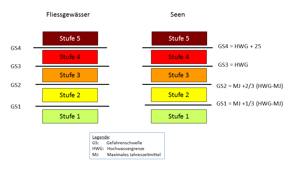
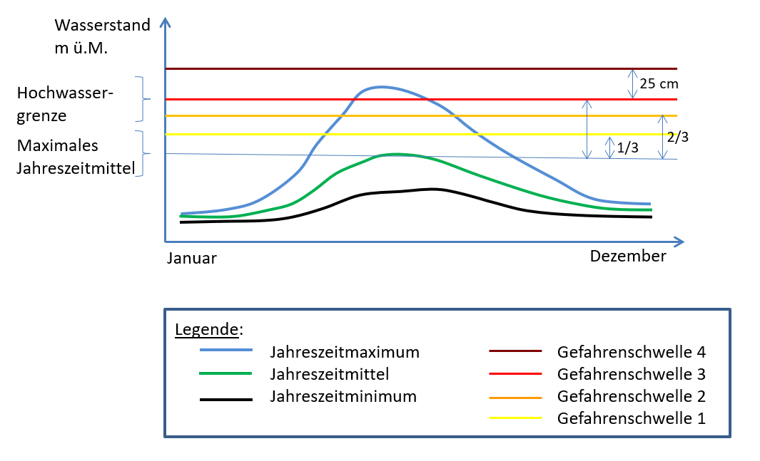
Definition of the danger levels for rivers and lakes
For rivers:
At the stations which have some experience of the danger posed by flooding, the thresholds are adapted selectively by agreement between the Confederation and the Cantons. The thresholds for the other stations, including those with small catchment areas, are based on the rounded flood recurrence intervals HQ2, HQ10, HQ30.
Example:
The danger thresholds may differ from the statistical thresholds, as in the example below:
| Recurrence interval | Statistical threshold | Rounded threshold | Adapted threshold |
| HQ2 | 572 | 570 | 590 |
| HQ10 | 819 | 820 | 880 |
| HQ30 | 943 | 950 | 1050 |
| HQ100 | 1065 | 1100 | 1250 |
For lakes:
Flood statistics are not compiled for lakes. Therefore the warning thresholds are defined differently: The variance between summer high (SK) and flood limit (HWG) is divided into three equal ranges corresponding to danger levels 1, 2 and 3. The flood limit forms the transition between danger levels 3 and 4. Danger level 5 is reached if the lake level rises above the "Flood limit + 25 cm" warning threshold. The thresholds for lakes are also adapted if there is some experience of the danger from flooding, by agreement with the canton.